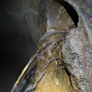
An exhibition of photographs and maps of Bounds Green Brook. This partially covered tributary of Pymmes Brook, the River Lea and finally the River Thames, rises on the northern slopes of Muswell Hill and the eastern slopes of Finchley. Over the last year, Ben has sought out – and climbed into – subterranean culverts to explore and photograph a paradoxical landscape of spring water and sewage due to drainage misconnections. Alongside he has gathered local people to share knowledge and test water quality in cemeteries, allotments and under the North Circular.
Events
Haringey Feast has now taken place, however there lots of creative events and activities happening across Haringey. Visit our Culture pages to find out more….
Wednesday 1 April 2026, 1.00pm to Sunday 5 April 2026, 5.00pm
An exhibition of photographs and maps of Bounds Green Brook. This partially covered tributary of Pymmes Brook, the River Lea and finally the River Thames, rises on the northern slopes of Muswell Hill and the eastern slopes of Finchley. Over the last year, Ben has sought out – and climbed into – subterranean culverts to explore and photograph a paradoxical landscape of spring water and sewage due to drainage misconnections. Alongside he has gathered local people to share knowledge and test water quality in cemeteries, allotments and under the North Circular.
Thursday 2 April 2026, 1.00pm to Monday 6 April 2026, 5.00pm
An exhibition of photographs and maps of Bounds Green Brook. This partially covered tributary of Pymmes Brook, the River Lea and finally the River Thames, rises on the northern slopes of Muswell Hill and the eastern slopes of Finchley. Over the last year, Ben has sought out – and climbed into – subterranean culverts to explore and photograph a paradoxical landscape of spring water and sewage due to drainage misconnections. Alongside he has gathered local people to share knowledge and test water quality in cemeteries, allotments and under the North Circular.
Friday 3 April 2026, 1.00pm to Tuesday 7 April 2026, 5.00pm
An exhibition of photographs and maps of Bounds Green Brook. This partially covered tributary of Pymmes Brook, the River Lea and finally the River Thames, rises on the northern slopes of Muswell Hill and the eastern slopes of Finchley. Over the last year, Ben has sought out – and climbed into – subterranean culverts to explore and photograph a paradoxical landscape of spring water and sewage due to drainage misconnections. Alongside he has gathered local people to share knowledge and test water quality in cemeteries, allotments and under the North Circular.
Saturday 4 April 2026, 1.00pm to Wednesday 8 April 2026, 5.00pm
An exhibition of photographs and maps of Bounds Green Brook. This partially covered tributary of Pymmes Brook, the River Lea and finally the River Thames, rises on the northern slopes of Muswell Hill and the eastern slopes of Finchley. Over the last year, Ben has sought out – and climbed into – subterranean culverts to explore and photograph a paradoxical landscape of spring water and sewage due to drainage misconnections. Alongside he has gathered local people to share knowledge and test water quality in cemeteries, allotments and under the North Circular.
Sunday 5 April 2026, 1.00pm to Thursday 9 April 2026, 5.00pm
An exhibition of photographs and maps of Bounds Green Brook. This partially covered tributary of Pymmes Brook, the River Lea and finally the River Thames, rises on the northern slopes of Muswell Hill and the eastern slopes of Finchley. Over the last year, Ben has sought out – and climbed into – subterranean culverts to explore and photograph a paradoxical landscape of spring water and sewage due to drainage misconnections. Alongside he has gathered local people to share knowledge and test water quality in cemeteries, allotments and under the North Circular.
Monday 6 April 2026, 1.00pm to Friday 10 April 2026, 5.00pm
An exhibition of photographs and maps of Bounds Green Brook. This partially covered tributary of Pymmes Brook, the River Lea and finally the River Thames, rises on the northern slopes of Muswell Hill and the eastern slopes of Finchley. Over the last year, Ben has sought out – and climbed into – subterranean culverts to explore and photograph a paradoxical landscape of spring water and sewage due to drainage misconnections. Alongside he has gathered local people to share knowledge and test water quality in cemeteries, allotments and under the North Circular.
Tuesday 7 April 2026, 1.00pm to Saturday 11 April 2026, 5.00pm
An exhibition of photographs and maps of Bounds Green Brook. This partially covered tributary of Pymmes Brook, the River Lea and finally the River Thames, rises on the northern slopes of Muswell Hill and the eastern slopes of Finchley. Over the last year, Ben has sought out – and climbed into – subterranean culverts to explore and photograph a paradoxical landscape of spring water and sewage due to drainage misconnections. Alongside he has gathered local people to share knowledge and test water quality in cemeteries, allotments and under the North Circular.
Wednesday 8 April 2026, 1.00pm to Sunday 12 April 2026, 5.00pm
An exhibition of photographs and maps of Bounds Green Brook. This partially covered tributary of Pymmes Brook, the River Lea and finally the River Thames, rises on the northern slopes of Muswell Hill and the eastern slopes of Finchley. Over the last year, Ben has sought out – and climbed into – subterranean culverts to explore and photograph a paradoxical landscape of spring water and sewage due to drainage misconnections. Alongside he has gathered local people to share knowledge and test water quality in cemeteries, allotments and under the North Circular.
Thursday 9 April 2026, 1.00pm to Monday 13 April 2026, 5.00pm
An exhibition of photographs and maps of Bounds Green Brook. This partially covered tributary of Pymmes Brook, the River Lea and finally the River Thames, rises on the northern slopes of Muswell Hill and the eastern slopes of Finchley. Over the last year, Ben has sought out – and climbed into – subterranean culverts to explore and photograph a paradoxical landscape of spring water and sewage due to drainage misconnections. Alongside he has gathered local people to share knowledge and test water quality in cemeteries, allotments and under the North Circular.
Friday 10 April 2026, 1.00pm to Tuesday 14 April 2026, 5.00pm
An exhibition of photographs and maps of Bounds Green Brook. This partially covered tributary of Pymmes Brook, the River Lea and finally the River Thames, rises on the northern slopes of Muswell Hill and the eastern slopes of Finchley. Over the last year, Ben has sought out – and climbed into – subterranean culverts to explore and photograph a paradoxical landscape of spring water and sewage due to drainage misconnections. Alongside he has gathered local people to share knowledge and test water quality in cemeteries, allotments and under the North Circular.
Saturday 11 April 2026, 1.00pm to Wednesday 15 April 2026, 5.00pm
An exhibition of photographs and maps of Bounds Green Brook. This partially covered tributary of Pymmes Brook, the River Lea and finally the River Thames, rises on the northern slopes of Muswell Hill and the eastern slopes of Finchley. Over the last year, Ben has sought out – and climbed into – subterranean culverts to explore and photograph a paradoxical landscape of spring water and sewage due to drainage misconnections. Alongside he has gathered local people to share knowledge and test water quality in cemeteries, allotments and under the North Circular.
Sunday 12 April 2026, 1.00pm to Thursday 16 April 2026, 5.00pm
An exhibition of photographs and maps of Bounds Green Brook. This partially covered tributary of Pymmes Brook, the River Lea and finally the River Thames, rises on the northern slopes of Muswell Hill and the eastern slopes of Finchley. Over the last year, Ben has sought out – and climbed into – subterranean culverts to explore and photograph a paradoxical landscape of spring water and sewage due to drainage misconnections. Alongside he has gathered local people to share knowledge and test water quality in cemeteries, allotments and under the North Circular.
Monday 13 April 2026, 1.00pm to Friday 17 April 2026, 5.00pm
An exhibition of photographs and maps of Bounds Green Brook. This partially covered tributary of Pymmes Brook, the River Lea and finally the River Thames, rises on the northern slopes of Muswell Hill and the eastern slopes of Finchley. Over the last year, Ben has sought out – and climbed into – subterranean culverts to explore and photograph a paradoxical landscape of spring water and sewage due to drainage misconnections. Alongside he has gathered local people to share knowledge and test water quality in cemeteries, allotments and under the North Circular.
Tuesday 14 April 2026, 1.00pm to Saturday 18 April 2026, 5.00pm
An exhibition of photographs and maps of Bounds Green Brook. This partially covered tributary of Pymmes Brook, the River Lea and finally the River Thames, rises on the northern slopes of Muswell Hill and the eastern slopes of Finchley. Over the last year, Ben has sought out – and climbed into – subterranean culverts to explore and photograph a paradoxical landscape of spring water and sewage due to drainage misconnections. Alongside he has gathered local people to share knowledge and test water quality in cemeteries, allotments and under the North Circular.
Wednesday 15 April 2026, 1.00pm to Sunday 19 April 2026, 5.00pm
An exhibition of photographs and maps of Bounds Green Brook. This partially covered tributary of Pymmes Brook, the River Lea and finally the River Thames, rises on the northern slopes of Muswell Hill and the eastern slopes of Finchley. Over the last year, Ben has sought out – and climbed into – subterranean culverts to explore and photograph a paradoxical landscape of spring water and sewage due to drainage misconnections. Alongside he has gathered local people to share knowledge and test water quality in cemeteries, allotments and under the North Circular.
Thursday 16 April 2026, 1.00pm to Monday 20 April 2026, 5.00pm
An exhibition of photographs and maps of Bounds Green Brook. This partially covered tributary of Pymmes Brook, the River Lea and finally the River Thames, rises on the northern slopes of Muswell Hill and the eastern slopes of Finchley. Over the last year, Ben has sought out – and climbed into – subterranean culverts to explore and photograph a paradoxical landscape of spring water and sewage due to drainage misconnections. Alongside he has gathered local people to share knowledge and test water quality in cemeteries, allotments and under the North Circular.
Friday 17 April 2026, 1.00pm to Tuesday 21 April 2026, 5.00pm
An exhibition of photographs and maps of Bounds Green Brook. This partially covered tributary of Pymmes Brook, the River Lea and finally the River Thames, rises on the northern slopes of Muswell Hill and the eastern slopes of Finchley. Over the last year, Ben has sought out – and climbed into – subterranean culverts to explore and photograph a paradoxical landscape of spring water and sewage due to drainage misconnections. Alongside he has gathered local people to share knowledge and test water quality in cemeteries, allotments and under the North Circular.
Saturday 18 April 2026, 1.00pm to Wednesday 22 April 2026, 5.00pm
An exhibition of photographs and maps of Bounds Green Brook. This partially covered tributary of Pymmes Brook, the River Lea and finally the River Thames, rises on the northern slopes of Muswell Hill and the eastern slopes of Finchley. Over the last year, Ben has sought out – and climbed into – subterranean culverts to explore and photograph a paradoxical landscape of spring water and sewage due to drainage misconnections. Alongside he has gathered local people to share knowledge and test water quality in cemeteries, allotments and under the North Circular.
Sunday 19 April 2026, 1.00pm to Thursday 23 April 2026, 5.00pm
An exhibition of photographs and maps of Bounds Green Brook. This partially covered tributary of Pymmes Brook, the River Lea and finally the River Thames, rises on the northern slopes of Muswell Hill and the eastern slopes of Finchley. Over the last year, Ben has sought out – and climbed into – subterranean culverts to explore and photograph a paradoxical landscape of spring water and sewage due to drainage misconnections. Alongside he has gathered local people to share knowledge and test water quality in cemeteries, allotments and under the North Circular.